Cyclone Biparjoy Approaches Indian Coast
The India Meteorological Department (IMD) has issued a warning about Cyclone Biparjoy, a very severe cyclonic storm, approaching the Indian coast.
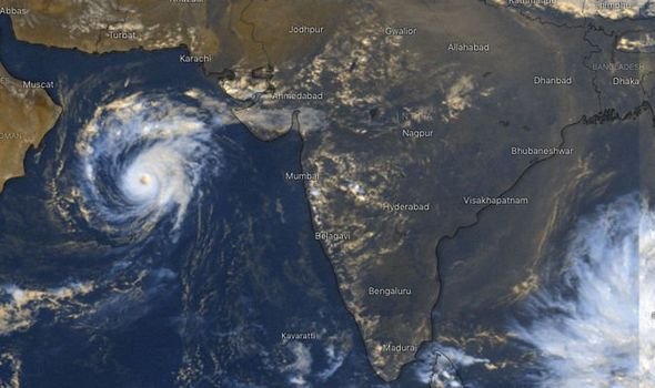
The India Meteorological Department (IMD) has issued a warning about Cyclone Biparjoy, a very severe cyclonic storm, approaching the Indian coast. The cyclone, which originated in the Arabian Sea, is expected to make landfall between Mandvi in Gujarat and Karachi in Pakistan on June 15. Currently classified as an extremely severe cyclonic storm, it has been causing winds of up to 190 kmph in the sea.
According to IMD scientist Monika Sharma, the cyclone's intensity is expected to slightly decrease before it reaches the coast. The IMD has issued warnings for heavy rainfall, storm surges, and high winds of about 125-135 kmph in the coastal districts. A yellow alert has been issued for Gujarat and Kutch, with heavy rainfall predicted for several districts.
The cyclone's current location is approximately 580 km west-southwest of Mumbai, 480 km south-southwest of Porbandar, 530 km south-southwest of Devbhumi Dwarka, 610 km south-southwest of Naliya, and 780 km south of Karachi.
The IMD predicts that the cyclone will move northward until the morning of June 14, then shift to a north-northeast direction. It is expected to cross Saurashtra, Kutch, and adjoining Pakistan coasts between Mandvi and Karachi on June 15, with maximum sustained wind speeds of 125-135 kmph gusting to 150 kmph.
On June 15, heavy to very heavy rainfall is expected in Kutch, Devbhumi Dwarka, Jamnagar, Porbandar, Rajkot, Morbi, and Junagarh districts. Sea conditions will be rough to very rough until June 14 evening, becoming high to phenomenal thereafter until June 15 noon.
The cyclone's impact may include destruction of thatched houses, damage to kutcha houses, and potential damage to pucca houses. Minor disruptions to railways, power lines, and signaling systems are also anticipated, along with damage to crops, plantations, and coconut trees.
Fishing operations in the east central and adjoining west central Arabian Sea have been advised to be completely suspended until June 15.
The occurrence of cyclones in the Arabian Sea during June is not uncommon. However, the warm sea surface temperatures have been contributing to the intensification of storms in the Indian Ocean, with cyclones growing stronger at a faster rate.
In the case of Cyclone Biparjoy, a low-pressure area formed over the southeast Arabian Sea on June 5 and quickly intensified into a depression. Within 12 hours, it became a deep depression, and by June 7, it turned into a cyclonic storm. Within the following 12 hours, it escalated to a very severe cyclonic storm. As of now, it has further intensified into an extremely severe cyclonic storm.
What's Your Reaction?